
|
|
Qu'Appelle Valley Geolog Stop 5 -
Lebret Landslide
[ Previous Stop ] [ Next Stop ] 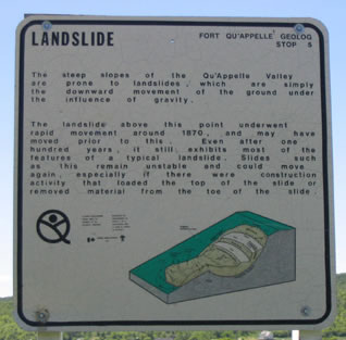
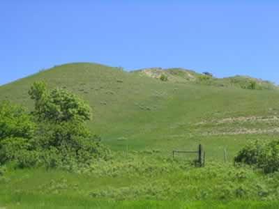
The Lebret Landslide can be seen from the roadside of Highway 56. Although it is at least 100 years old, it is still very visible as little erosion has occurred in this area. GeologyThe Lebret Landslide is a slow-moving landslide; the land is very unstable under the surface and in some cases is constantly sliding downward due to gravity. Landslides involve large amounts of energy, much larger than man can resist. Slow-moving landslides are dangerous because it takes very little disturbance to get them moving again if they are inactive. This can cause such a slow rate of structural damage to roads, buildings, dams, and town sites that can take years to notice. Unlike fast-moving landslides, which cause damage quickly and noticeably, slow-moving landslides cause their damage over time, pressing and shifting under man-made structures. In most cases it is unwise to build on an inactive landslide, unless a Geologist has inspected the area and declared it safe. Geologists believe the Lebret Landslide formed as a result of movement along a water-bearing sandy silt and sand layer that dips toward the Qu'Appelle Valley. Porewater pressure on the sandy silt layer can cause the shearing resistance along the shearing surface to weaken and collapse under the weight of the water, causing a landslide. In the case of the Lebret Landslide, a scarp formed in the valley side, and a slump ridge formed down slope from the scarp as a result of the rotation of the landslide on the curved shearing surface. The land at Stop 5 is characterized by many rocks and the surface is very hummocky. The land is on the north slope of the valley which creates a drier, more desert-like conditions as it is subjected to more sunlight than southern slopes. As a result, plant growth stays rather short, having only sages, low grasses, milk-vetches, and relatively few low shrub species. Regrettably, Stop 5 is not accessible to the public as it is located on private land.
Plant species found at stop 5:
|
Page last updated on
2004-10-08 |