
|
|
Qu'Appelle Valley Geolog Stop 6 - Katepwa Provincial Park
[ Previous Stop ] [ Next Stop ] 
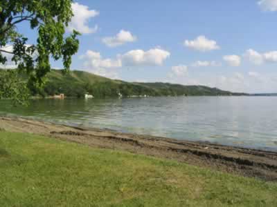
Stop 6 is located inside Katepwa Provincial Park, and is probably the most developed of all the original Geolog Tour stops. Most of the vegetation in the park has been introduced and consists of evergreens and grasses. The beaches have at points been filled with sand to make the area more welcoming for tourists. Across the highway from the park, the Trans Canada Trail is in development, further expanding the park's tourism opportunities. Along the trail there are more naturally occurring species, including Twining honeysuckle, Western snowberry, and Common hop. Geology Katepwa Provincial Park was chosen for the original Geolog Tour because it is a good example of tributaries, and of how groundwater and surface water interact. The three tributaries in Katepwa Lake evolved after the Qu'Appelle Valley was cut by meltwater. As the water bearing Echo Lake Gravel was penetrated, large quantities of groundwater discharged from this aquifer into the Qu'Appelle Valley in the form of major springs. This process is called "spring sapping," and it causes the sand and gravel under the surface to erode and shift. For Katepwa Beach, this loss of sand and gravel caused the overlying till to collapse. The pressure and movement caused by this collapse formed fans along both sides of the water. Currently these fans are being filled with alluvium, raising their soil levels and evening out the surface. Groundwater is collected when rain and melted snow sink underground to the Echo Lake Gravel and Empress deposits*. This water then flows vertically into the Qu'Appelle alluvium, and feeds into Katepwa Lake. When lake levels fall, more groundwater is discharged into them. On the other hand, when lake levels rise groundwater discharge is suppressed and stored underground. Aerial Photo Click here to see an aerial photograph of stop 6.
Plant species found at stop 6:
|
Page last updated on
2004-10-08 |